Better Use of Remote Sensing and In Situ Observing Systems for Coastal Regional Seas

ECOOP WP7, led by Pierre Yves LE TRAON, aims to improve the use of existing remote sensing and in situ data for coastal and regional seas, as well as develop synergies between observing networks. The focus is on validation, assimilation or use of data for model or forcing validation. Potential partners include CLS, LEGOS, ICM, IFREMER, BOOST, CNR, INGV, UKMO, DMI, Met no, NERSC, ESEAS, MERSEA and MFS consortiums.
- Uploaded on | 1 Views
-
 lucaslo
About Better Use of Remote Sensing and In Situ Observing Systems for Coastal Regional Seas
PowerPoint presentation about 'Better Use of Remote Sensing and In Situ Observing Systems for Coastal Regional Seas'. This presentation describes the topic on ECOOP WP7, led by Pierre Yves LE TRAON, aims to improve the use of existing remote sensing and in situ data for coastal and regional seas, as well as develop synergies between observing networks. The focus is on validation, assimilation or use of data for model or forcing validation. Potential partners include CLS, LEGOS, ICM, IFREMER, BOOST, CNR, INGV, UKMO, DMI, Met no, NERSC, ESEAS, MERSEA and MFS consortiums.. The key topics included in this slideshow are Remote sensing, in situ observation, regional seas, coastal areas, validation,. Download this presentation absolutely free.
Presentation Transcript
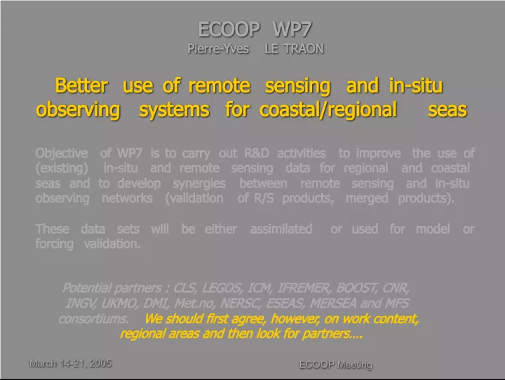
1. ECOOP Meeting ECOOP Meeting March 14-21, 2005 March 14-21, 2005 ECOOP WP7 Pierre-Yves LE TRAON ECOOP WP7 Pierre-Yves LE TRAON Better use of remote sensing and in-situ observing systems for coastal/regional seas Better use of remote sensing and in-situ observing systems for coastal/regional seas Objective of WP7 is to carry out R&D activities to improve the use of (existing) in-situ and remote sensing data for regional and coastal seas and to develop synergies between remote sensing and in-situ observing networks (validation of R/S products, merged products). These data sets will be either assimilated or used for model or forcing validation. Potential partners : CLS, LEGOS, ICM, IFREMER, BOOST, CNR, INGV, UKMO, DMI, Met.no, NERSC, ESEAS, MERSEA and MFS consortiums. We should first agree, however, on work content, regional areas and then look for partners.
2. March 14-21, 2005 ECOOP Meeting 2 WP7.1 Optimal synergy between altimetry and tide gauge (TG) data WP7.1 Optimal synergy between altimetry and tide gauge (TG) data Analyze the consistency between altimeter data sets and all coastal tide gauge data (link with ESEAS, BOOS, NOOS, ) in the ECOOP regional seas Analyze the consistency between altimeter data sets and all coastal tide gauge data (link with ESEAS, BOOS, NOOS, ) in the ECOOP regional seas Use TG to improve the altimeter processing in regional/coastal seas (high frequency corrections, tidal corrections, processing techniques) so that differences between altimetry and tide gauges can be reduced. Use TG to improve the altimeter processing in regional/coastal seas (high frequency corrections, tidal corrections, processing techniques) so that differences between altimetry and tide gauges can be reduced. Merge TG and altimeter data sets to improve the sampling along the coasts. Merge TG and altimeter data sets to improve the sampling along the coasts. WP7.2 Mean sea level in coastal/regional seas to reference altimeter data WP7.2 Mean sea level in coastal/regional seas to reference altimeter data Because of geoid uncertainties, altimetry provides only sea level anomaly data. GOCE (2006) will provide very accurate geoid models that will have a major impact on the use of altimetry in regional seas (absolute sea level). Because of geoid uncertainties, altimetry provides only sea level anomaly data. GOCE (2006) will provide very accurate geoid models that will have a major impact on the use of altimetry in regional seas (absolute sea level). Improved high resolution mean dynamic topographies should thus be developed from GOCE and altimeter data for regional/coastal seas + analyze the impact of MDT on altimeter data use and assimilation in regional/coastal models. Improved high resolution mean dynamic topographies should thus be developed from GOCE and altimeter data for regional/coastal seas + analyze the impact of MDT on altimeter data use and assimilation in regional/coastal models.
3. March 14-21, 2005 ECOOP Meeting 3 WP7.4 Improved Ocean Colour products for Case-II waters WP7.4 Improved Ocean Colour products for Case-II waters Ocean Colour in coastal seas is a very difficult issue due to the composition and optical properties of these waters (case 2). There is a continuing need to improve and test algorithms for: Ocean Colour in coastal seas is a very difficult issue due to the composition and optical properties of these waters (case 2). There is a continuing need to improve and test algorithms for: estimating phytoplankton, yellow substance and suspended material in Case 2 waters. estimating phytoplankton, yellow substance and suspended material in Case 2 waters. atmospheric algorithms correction. atmospheric algorithms correction. Algorithms should be validated/tuned with in-situ data for the different coastal regions. The design of in-situ monitoring systems should take into account this requirement. Algorithms should be validated/tuned with in-situ data for the different coastal regions. The design of in-situ monitoring systems should take into account this requirement. WP7.5 Improved Sea Surface Temperature products (GHRSST-PP) WP7.5 Improved Sea Surface Temperature products (GHRSST-PP) Analyse the availability of Ultra high Res. SST products for coastal seas (L2P data) (1 km, < 1 day) in relation with MERSEA and the ESA Medspiration project (GHRSST-PP). For analyzed products (L4), one should refine optimal interpolation schemes and develop the merging with in-situ data. Analyse the availability of Ultra high Res. SST products for coastal seas (L2P data) (1 km, < 1 day) in relation with MERSEA and the ESA Medspiration project (GHRSST-PP). For analyzed products (L4), one should refine optimal interpolation schemes and develop the merging with in-situ data. Develop high res. SST regional climatologies. Develop high res. SST regional climatologies.
4. March 14-21, 2005 ECOOP Meeting 4 WP7.3 New surface current products WP7.3 New surface current products High resolution surface currents are critical for most applications and new products should be developed. The following R&D activities are envisioned: High resolution surface currents are critical for most applications and new products should be developed. The following R&D activities are envisioned: Use of high resolution SST and Ocean Colour data to provide estimation of surface currents together with satellite altimetry. Develop innovative techniques. Use of high resolution SST and Ocean Colour data to provide estimation of surface currents together with satellite altimetry. Develop innovative techniques. Use of HF radars. Use of HF radars. Use of SAR data for surface currents. Use of SAR data for surface currents. Compare and merge all these data sets with in-situ data (buoys, ADCP). Compare and merge all these data sets with in-situ data (buoys, ADCP). Develop improved climatologies for surface currents. Develop improved climatologies for surface currents.
5. March 14-21, 2005 ECOOP Meeting 5 WP7.6 Innovative in-situ monitoring systems WP7.6 Innovative in-situ monitoring systems Cost-effective technology such as ferrybox, bottom-moored profilers, gliders and towed profilers should be developed/tested to complement existing in- situ monitoring networks. Cost-effective technology such as ferrybox, bottom-moored profilers, gliders and towed profilers should be developed/tested to complement existing in- situ monitoring networks. As part of this task, a survey and critical analysis of technologies in use and applied procedures for maintenance and on site operations have to be conducted. As part of this task, a survey and critical analysis of technologies in use and applied procedures for maintenance and on site operations have to be conducted. Tests should be conducted with new instrumentation for coastal/regional areas (e.g. coastal profilers developed at Ifremer, etc) and impact in modelling/assimilation systems should be assessed. Tests should be conducted with new instrumentation for coastal/regional areas (e.g. coastal profilers developed at Ifremer, etc) and impact in modelling/assimilation systems should be assessed.
6. March 14-21, 2005 ECOOP Meeting 6 WP7.7 Improved wind products in coastal seas WP7.7 Improved wind products in coastal seas Coastal/regional systems require forcing fields at high space and time resolution. These will mainly come from local high resolution NWP systems. Coastal/regional systems require forcing fields at high space and time resolution. These will mainly come from local high resolution NWP systems. Information from satellites (scatterometry and SAR) in coastal/regional seas should provide very useful complementary information (in particular, high resolution wind fields from SAR imagery). Information from satellites (scatterometry and SAR) in coastal/regional seas should provide very useful complementary information (in particular, high resolution wind fields from SAR imagery). Such information will be essential to validate local atmospherical NWP. Such information will be essential to validate local atmospherical NWP. In the future, these satellite data sets should be merged with NWP model outputs using simple techniques or through data assimilation. In the future, these satellite data sets should be merged with NWP model outputs using simple techniques or through data assimilation.
7. ECOOP Meeting ECOOP Meeting March 14-21, 2005 March 14-21, 2005 Issues for WP7 Issues for WP7 Quality of assimilated regional/coastal products will (highly) depend on the quality of input data. Need R&D on R/S-in-situ data (WP7). Focus the WP7 (R&D) work on specific regions ? Issues for other WPs in ECOOP Need efficient data processing and data distribution systems with long- term commitment. ECOOP must rely and establish strong links with MERSEA thematic centers/portals (this is critical for the overall GMES architecture) Need to establish links between WP7 and production WPs for in-situ and remote sensing data (transfer of R&D results). Work should be planned in R&D assimilation to assess the value of improved remote sensing/in-situ products. + organize real time access to European tide gauge