Waves, Wind, and Glaciers: Erosion and Deposition

This article explores the processes of erosion and deposition caused by waves, wind, and glaciers. Waves form as a result of wind energy blowing across the surface
- Uploaded on | 1 Views
-
 matteo
About Waves, Wind, and Glaciers: Erosion and Deposition
PowerPoint presentation about 'Waves, Wind, and Glaciers: Erosion and Deposition'. This presentation describes the topic on This article explores the processes of erosion and deposition caused by waves, wind, and glaciers. Waves form as a result of wind energy blowing across the surface. The key topics included in this slideshow are . Download this presentation absolutely free.
Presentation Transcript
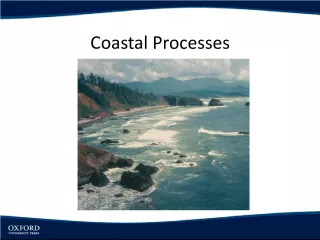
Slide1WAVES, WIND, ANDGLACIERS Erosion and Deposition
Slide2How Waves Form The energy in waves from wind that blows across the water’s surface.
Slide3Erosion by Waves Waves shape the coast through erosion by breaking down rock and transporting sand and other sediment.
Slide4How Waves Erode Land Impact Abrasion Change in Wave Direction
Slide5Headland Part of the shore that sticks out into the ocean. Example: Marin Headland
Slide6Erosional Features of WavesWave-Cut Cliff Headland Sea Cave Sea Arch
Slide7Depostional Features of WavesBeach Spit Sandbar
Slide8Wave Erosion & Deposition Landforms
Slide9Erosion by Wind Wind causes erosion by deflation and abrasion.
Slide10Deflation The erosion of sediment by wind. Stronger the wind, the larger the particles it can pick up.
Slide11Deposits By WindSand Dunes • Deposit of wind-blown sand. Loess • Wind-formed deposit made of fine particles of clay and silt.
Slide12Glacier Any large mass of ice that moves slowly over land.
Slide13Plucking The process by which a glacier picks up rocks as it flows over the land.
Slide14Till A mass of rock and soil deposited directly by a glacier.
Slide15Two Kinds of GlaciersContinental Glacier Valley Glacier
Slide16Continental Glacier A glacier that covers much of a continent or large island. Can cover millions of square kilometers. Antarctica and Greenland. Can flow in all directions. Can spread out like pancake butter in a frying pan.
Slide17Ice Ages In the past, continental glaciers have covered larger parts of the Earth’s surface.
Slide18Valley Glaciers A long, narrow glacier that forms when snow and ice build up high in a mountain valley. The sides of mountains keep these glaciers from spreading out in all directions. Found in many high mountains. Sierra Nevada and Mount Shasta.
Slide19Glaciers Glaciers can form only in an area where more snow falls than melts. Once the depth of snow and ice reaches more than 30 to 40 meters, gravity begins to pull the glacier downhill.
Slide20How Glaciers Shape the LandPlucking Picks up rocks as it moves Carries rocks with it as it moves Abrasion Gouges and scratches the bedrock Allows for rock to be picked up by plucking
Slide21Plucking and Abrasion
Slide22Glacial Deposition When a glacier melts, it deposits the sediment it eroded from the land, creating various landforms.
Slide23Glacial Deposition LandformsTill • Mixture of sediments that a glacier deposited on the surface. Moraine • Till that is deposited at the edges of a glacier forms a ridge. Kettle Lake • Forms when a depression left in a till by melting ice fills with water.
Slide24Glacial Landforms
Slide25Credits Geo Resources http://www.google.com/imgres?hl=en&biw=1169&bih=663&tbm=isch&tbnid=NEojdsvuGCLF8M:&imgrefurl=http://www.georesources.co.uk/leld.htm&docid=IGXmJeec1Qr11M&imgur l=http://www.georesources.co.uk/sea6.gif&w=380&h=292&ei=P_5nT_2FI6yMigLawKmgBw&zoom=1&iact=hc&vpx=480&vpy=226&dur=1544&hovh=197&hovw=256&tx=159&ty=83&sig =102853300329707996231&page=2&tbnh=145&tbnw=189&start=15&ndsp=20&ved=1t:429,r:7,s:15 Association of Environmental & Engineering Geologists. Retrieved on 3/19/2012. http://www.google.com/imgres?hl=en&biw=1169&bih=663&tbm=isch&tbnid=xXW6jQgEKQBf_M:&imgrefurl=http://www.aegweb.org /i4a/pages/index.cfm%3Fpageid%3D4083&docid=EmzY2eWlU_R95M&imgurl=http://www.aegweb.org/images/Geologic%252520Haza rds/erodedbeach.gif&w=400&h=280&ei=P_5nT_2FI6yMigLawKmgBw&zoom=1&iact=hc&vpx=491&vpy=157&dur=3908&hovh=188&h ovw=268&tx=171&ty=55&sig=102853300329707996231&page=1&tbnh=134&tbnw=191&start=0&ndsp=15&ved=1t:429,r:2,s: