Uncovering the Mystery of Glaciers
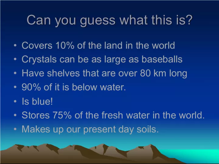

Can you guess what this is? It covers 10% of the land in the world and has crystals as large as baseballs. Its shelves can be over 80 km long and
- Uploaded on | 0 Views
-
 neeakotila
About Uncovering the Mystery of Glaciers
PowerPoint presentation about 'Uncovering the Mystery of Glaciers'. This presentation describes the topic on Can you guess what this is? It covers 10% of the land in the world and has crystals as large as baseballs. Its shelves can be over 80 km long and. The key topics included in this slideshow are . Download this presentation absolutely free.
Presentation Transcript
Slide1Can you guess what this is? Can you guess what this is? • Covers 10% of the land in the world • Crystals can be as large as baseballs • Have shelves that are over 80 km long • 90% of it is below water. • Is blue! • Stores 75% of the fresh water in the world. • Makes up our present day soils.
Slide2•Covers 10% of the land in the world Presently 10% of all land is covered by glaciers. Crystals can be as large as baseballs Glacier ice crystals can be this size!!
Slide3Have shelves that are over 80 km long Have shelves that are over 80 km long • Antartica’s glaciers have calve ice shelves that may be over 80 km long.
Slide4 90% of it is below water. • • 90% of the iceberg is below water— what you see is only 10% above the water!!
Slide5•Is Blue!!! • Glacial ice is white when there are many air bubbles, but ice is extremely compacted and dense, ice is blue. • Stores 75% of the fresh water in the world. • 75% of the freshwater is frozen in the glaciers and is unavailable for our use.
Slide6GLACIATIONGLACIATION Environmental Science Environmental Science
Slide7Earth’s Glaciers Earth’s Glaciers
Slide8GlaciersGlaciers • Cover 10% of Earth’s surface. • Majority of glacial ice is tied up in Anarctica and Greenland. • Also found in sub-polar and polar coastline mountain ranges in the world.
Slide9Glacial Formation Glacial Formation Glacier: an accumulation of snow that lasts for more than one year. As snow accumulates, compresses layers below to form ice—takes thousands of years.
Slide10Glacial Formation Glacial Formation Glaciers appear blue b/c they are so thick. Glacial Bay Glacier
Slide12Schwarze Schneid mountain at the Soelden glacier. Schwarze Schneid mountain at the Soelden glacier.
Slide13Largest Glacier in world Largest Glacier in world • http://science.howstuffworks.com/glacier.h tm#
Slide14Glaciers andLatitude
Slide15Glaciers in North America Glaciers in North America Glaciers made most of the landforms we have in Illinois incl: • Glacial lakes • Kettle lakes • Till • Moraines
Slide16Glaciersbegan in northern Canada
Slide17Glacial Formation Glacial Formation • http://maps.howstuffworks.com/maps-of- greenland.htm • How the Great Lakes were formed: • http://www.on.ec.gc.ca/greatlakeskids/Gre atLakesMovie5.html
Slide18Northern Illinois glaciers Northern Illinois glaciers
Slide19Illinois Landscape Illinois Landscape Current landscape shaped by: -Ice sheet was 1 mile thick -Occurred 25,000-14,000 ya -Ice (Laurentide period) covered much of Canada and northern US -Formed Lake Michigan
Slide20Landforms created by glaciers from Canada Landforms created by glaciers from Canada Continental glaciers Invaded IL repeatedly during the Ice Age. Ice Age lasted 2.4 Mya to 10,000 ya.
Slide21Geologists believe that this what northern IL looked like Geologists believe that this what northern IL looked like
Slide22Ice Sheet Ice Sheet Ice Sheet invasion From Canada flowed into NE Illinois and Lake Michigan.
Slide23GlaciationGlaciation • Climate and temperatures different during IL Ice Ages – Temperature at or near freezing – Precipitation in form of snow – Mastodons and Woolly Mammoths roamed the region.
Slide24MorainesMoraines Low rises of land caused By the invading and Retreating ice during Ice Ages.
Slide25Moraine Formation Moraine Formation
Slide26Moraine animation Moraine animation
Slide27TillTill Unsorted mixture of soil and debris form till (heavy sand & gravel outwash)
Slide28Kettle Lakes Kettle Lakes • Kettle lakes form when a block of buried ice left by the retreating glacier melts and forms a hole, sometimes quite deep.
Slide29Before Kettle Lake formed Before Kettle Lake formed Kettle lake to form here
Slide30Kettle lake forms Kettle lake forms
Slide31Bull Frog Lakeis a kettle lake near Cook County Forest Preserve
Slide32Kames are: Kames are: Cone-shaped hills in areas of ground moraine. When the ice melts, the sediment filling these depressions is let down onto the land surface.
Slide33Eskers are: Eskers are: • elongated s-shaped or ridges in areas of ground moraine. When the glacier melts, the deposits that fill the tunnels are let down onto the surface as ridges.
Slide34Eskers & Kames Eskers & Kames